
Soubor:Europe 1815 map en.png

Velikost tohoto náhledu: 800 × 526 pixelů. Jiná rozlišení: 320 × 211 pixelů | 640 × 421 pixelů | 1 024 × 674 pixelů | 1 280 × 842 pixelů | 2 284 × 1 503 pixelů.
Původní soubor (2 284 × 1 503 pixelů, velikost souboru: 1,08 MB, MIME typ: image/png)
| Tento soubor pochází z Wikimedia Commons. Níže jsou zobrazeny informace, které obsahuje jeho tamější stránka s popisem souboru. |
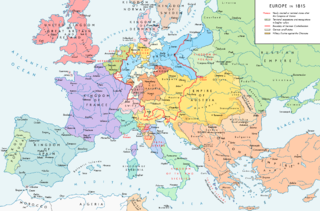
Map of Europe 1815, After the Congress of Vienna.
Popis
| Popis |
English: Europe 1815. Political situation after the Congress of Vienna in June 1815. Please don't alter the map when you think there is something not written or depicted correctly. Leave a message at the talk page of the file. After a verificiation and a possible discussion, I will upload a new map version with all new changes. This prevents an unnecessary waste of disk space and ensures a good result, aesthetically and content-wise. - The author. Español: Mapa de Europa en 1815. Situación política tras el Congreso de Viena en junio de 1815.
Deutsch: Europa 1815. Politische Lage nach dem Wiener Kongress im Juni 1815.
Bitte die Karte bei Änderungs- und Korrekturwünschen nicht selbst verändern, sondern eine Anmerkung im Diskussionsbereich der Bilddatei hinterlassen. Nach einer Prüfung und ggfs. Diskussion werden evtl. Änderungen von mir zusammengefasst eingearbeitet. Das vermeidet unnötige Speicherplatz-Verschwendung und gewährleistet ein ästhetisch ansprechendes und inhaltlich korrektes Ergebnis. - Der Urheber. Français : Carte de l'Europe en 1815. Situation politique après le Congrès de Vienne en juin 1815.
Italiano: Mappa dell'Europa nel 1815. Situazione politica dopo il Congresso di Vienna nel giugno 1815.
Русский: Карта Европы 1815 года. Политическая ситуация после Венского конгресса в июне 1815 года.
Português: Mapa da Europa em 1815. Situação política após o Congresso de Viena em junho de 1815. |
| Datum | |
| Zdroj |
Vlastní dílo. Source of Information: Historical atlases – Map "1815 - L'Europe après le Congrès de Vienne" (Author unknown)(Link) – Ramsay Muir, George Philip (ed.): Philip's New School Atlas of Universal History, George Philip & Son, Ltd., London 1928 – Dr. Walter Leisering (ed.): Putzger Historischer Weltatlas, Cornelsen Verlag, Berlin 1992, ISBN 3-464-00176-8 – Bayerischer Schulbuch-Verlag (ed.): Großer Historischer Weltatlas, Dritter Teil, Neuzeit, Bayerischer Schulbuch-Verlag, München 1981, ISBN 3-7627-6021-7. – Prof. Dr. Hans-Erich Stier, Prof. Dr. Ernst Kirsten a. o. (ed.): Großer Atlas zur Weltgeschichte, Orbis Verlag, München 1990, ISBN 3-7627-6021-7 Other publications – Reinhard Stauber: Der Wiener Kongress, Böhlau Verlag, Wien/Köln/Weimar 2014, ISBN 978-3-8252-4095-0 – Thierry Lentz: 1815. Der Wiener Kongress und die Neugründung Europas, Siedler Verlag, München 2014, ISBN 978-3-8275-0027-4 |
| Autor | Alexander Altenhof |
| Další verze |
|

Recompressed without quality loss with OptiPNG (1.36 MB > 1.06 MB)
Licence
Já, držitel autorských práv k tomuto dílu, ho tímto zveřejňuji za podmínek následující licence:
Tento soubor podléhá licenci Creative Commons Uveďte autora-Zachovejte licenci 4.0 International
- Dílo smíte:
- šířit – kopírovat, distribuovat a sdělovat veřejnosti
- upravovat – pozměňovat, doplňovat, využívat celé nebo částečně v jiných dílech
- Za těchto podmínek:
- uveďte autora – Máte povinnost uvést autorství, poskytnout odkaz na licenci a uvést, pokud jste provedli změny. Toho můžete docílit jakýmkoli rozumným způsobem, avšak ne způsobem naznačujícím, že by poskytovatel licence schvaloval nebo podporoval vás nebo vaše užití díla.
- zachovejte licenci – Pokud tento materiál jakkoliv upravíte, přepracujete nebo použijete ve svém díle, musíte své příspěvky šířit pod stejnou nebo slučitelnou licencí jako originál.

|
Tento obrázek (skupina map) by měl být vytvořen pomocí vektorové grafiky jako SVG soubor. To má několik výhod; podrobnosti najdete na stránce Commons:Media for cleanup. Je-li SVG verze tohoto obrázku již k dispozici, prosím nahrajte ji. Po nahrání nahraďte tuto šablonu šablonou {{Vector version available|jméno nového obrázku.svg}}.
|
Historie souboru
Kliknutím na datum a čas se zobrazí tehdejší verze souboru.
| Datum a čas | Náhled | Rozměry | Uživatel | Komentář | |
|---|---|---|---|---|---|
| současná | 15. 4. 2017, 01:36 | | 2 284 × 1 503 (1,08 MB) | KaterBegemot | Corrected "K. of Bavaria" caption / minor changes |
| 11. 9. 2016, 23:50 |  | 2 284 × 1 503 (1,36 MB) | KaterBegemot | Kingdom of Spain same green color like in the other maps | |
| 11. 9. 2016, 23:38 |  | 2 284 × 1 503 (1,06 MB) | KaterBegemot | Deleted black border at Austrian part of the German Confederation border, P. of Monaco smaller, corrected border at Tarnopol area, changed spacing of K. of Netherlands text | |
| 20. 7. 2016, 13:23 |  | 2 284 × 1 503 (1,07 MB) | KaterBegemot | {{Information |Description ={{en|1=Europe 1815. Political situation after the Congress of Vienna in June 1815.<br> ''Please don't alter the map, when you think there something not written or depicted correclty. Leave a mes... |
Využití souboru
Tento soubor používá následující stránka:
Globální využití souboru
Tento soubor využívají následující wiki:
- Využití na avk.wikipedia.org
- Využití na azb.wikipedia.org
- Využití na bg.wikipedia.org
- Využití na bs.wikipedia.org
- Využití na da.wikipedia.org
- Využití na el.wikipedia.org
- Využití na eml.wikipedia.org
- Využití na en.wikipedia.org
- Europe
- History of Europe
- 1810s
- History of Austria
- Congress of Vienna
- Napoleonic Wars
- History of the Czech lands
- Klemens von Metternich
- Karl August von Hardenberg
- Concert of Europe
- Former countries in Europe after 1815
- Balance of power (international relations)
- Monarchies in Europe
- Federal Convention (German Confederation)
- Portal:Czech Republic
- European balance of power
- 19th century
- International relations (1814–1919)
- Timeline of Karl Marx
- Timeline of the 19th century
- User:Falcaorib
- Secret Treaty of Vienna
- Talk:Europe/Archive 11
- User:SocratesGR
- Využití na en.wikibooks.org
- Využití na en.wikiquote.org
- Využití na eo.wikipedia.org
- Využití na eo.wikiquote.org
- Využití na es.wikipedia.org
- Využití na et.wikipedia.org
- Využití na eu.wikipedia.org
- Využití na fa.wikipedia.org
- Využití na fi.wikipedia.org
- Využití na fr.wikipedia.org
Zobrazit další globální využití tohoto souboru.